Watch Storm Chasers Get Close to a Monster Twister in Iowa Friday
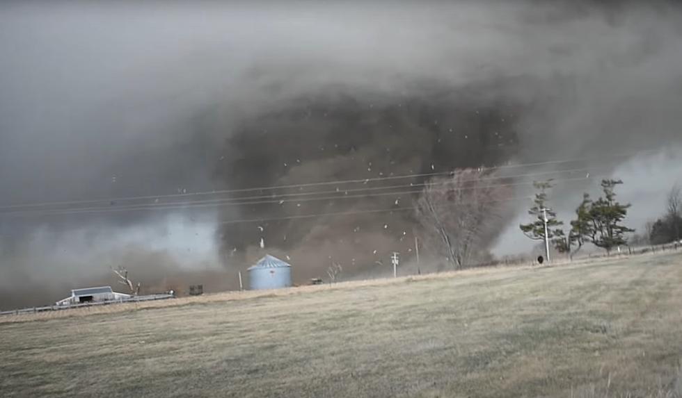
There have been very few weather days quite like what transpired on March 31, 2023. Among the more than 100 confirmed tornadoes was a monster wedge in Keota, Iowa that storm chasers got up-close-and-personal with.

Jayden Smith of Midwest Storm Chasing shared this incredible video on YouTube with this backstory:
The first SPC issued "High Risk" (level 5/5) in over 2 years brought multiple strong-to-violent tornadoes to eastern Iowa on March 31st, 2023. This video includes footage from 2 or possibly 3 of those tornadoes, all spawned by the same parent supercell, as well as an intercept of a tornado-warned QLCS south of Iowa City, which brought large hail and high winds, along with torrential rain.
They were able to witness the genesis of this tornadic system that eventually spawned multiple tornadoes including a monster multiple vortex wedge.
The preliminary estimation by the National Weather Service is that the wedge in the video was an EF-3. According to the Enhanced Fujita Scale, that would clock the winds in this twister between 135 and 165 mph. There will be teams from the National Weather Service providing more specific information once they complete their survey of this tornado's track.
As Jayden and his team shared near the end of the video, there was sadly massive damage of many farms and homes. Miraculously, you can watch the wedge also barely miss other homes and cattle.
It's worth remembering that NOAA's Storm Prediction Center is saying there is a possible repeat of severe storm activity on Tuesday, April 4, 2023 as conditions will once again be favorable for this kind of explosive weather development.
KEEP READING: Get answers to 51 of the most frequently asked weather questions...

More From KRFO-FM